NC ENVIROSCAN tool shared with environmental professionals interested in environmental justice
UNC SRP Community Engagement Core’s Dr. Andrew George, and the Administrative Core’s Dr. Lauren Eaves demonstrated use of the NC ENVIROSCAN tool with environmental professionals at the 2024 North Carolina Conservation Network conference in Raleigh, NC in May.
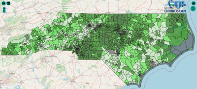
NC ENVIROSCAN shows average manganese levels in census tracts across the state. The lightest colors have levels below 35 parts per billion (ppb) and the darkest greens have levels equal to or above 100 ppb.
The NC ENVIROSCAN mapping tool combines data about environmental contaminants, including statewide private well testing data, socioeconomic factors, environmental justice indicators and health outcomes across the state. These data can be used to advance environmental justice efforts by helping users locate contaminants that may put people at risk, especially those who use private well water. The tool can be used to examine trends across counties, census tracts or zoom in to individual addresses to view contaminants in surrounding census tracts.
Well testing data included in NC ENVIROSCAN comes from the NCWELL database, which was developed by Eaves and others in 2021 (Eaves et al., 2022). This dataset includes all well water tests conducted by the State Laboratory of Public Health from 1998-2019. While this is one of the most comprehensive resources on contaminants in private wells, given limited testing there remain gaps in researchers’ understanding of where people are at greatest risk of exposure to toxic metals.
Participants in the session provided feedback about what users might want to see in the next iteration of the ENVIROSCAN tool, which is currently under development. New features may include the ability to upload or download data, improved ease of use for mapping several variables at once, and specialized logins for different types of users. Participants noted that they would like to be able to use coordinates to find hard-to-search locations and to be able to explore data by filtering by year.
This presentation was part of a panel of presentations on environmental justice and mapping; other panelists covered mapping to track landfill waste and using story maps to allow communities to gather data about their area and tell their stories.
By: Chase Bergeson, UNC SRP Research Translation Associate